Available Sizes: 1024x838 | 2048x1677 | 3366x2757
Download: JPG (1105 KB)
Date Uploaded: May 22, 2024
Permanent Link: http://wnhpc.com/details/zb092xj0060
Source: Stanford Libraries
Source URL: https://exhibits.stanford.edu/mining/catalog/zb092xj0060
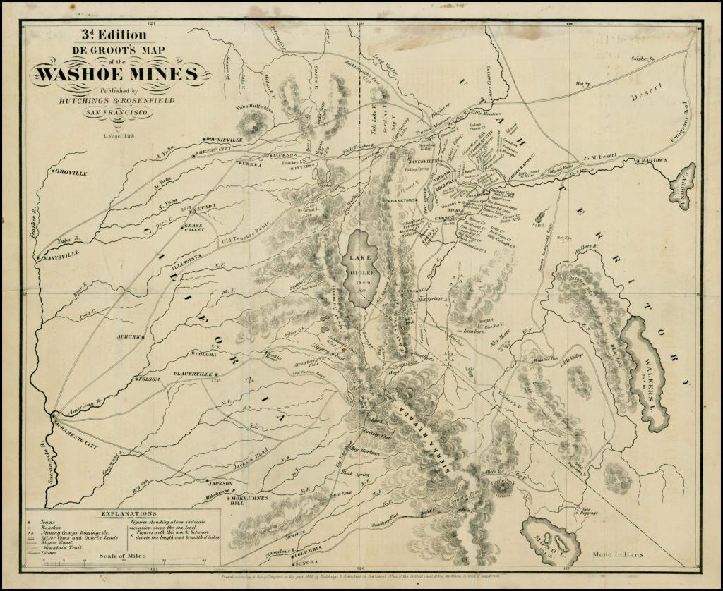
Source Caption: Nice example of De Groot's highly important map of the Washoe Mines, the first map to show the mining region and perhaps the single most important early map in the history of the yet to be formed Nevada Territory. The map is a tremendous source of information, both for its details in the portion of Utah Territory which would become Nevada and the routes used by California Gold Miners to the newly discovered diggings. The key identifies towns, ranchos, mining camps, wagon roads, mountain trails, ditches etc. As an early source of information for the region, it is unsurpassed. Henry De Groot was one of the first miners to make the trip from California to "Western Utah" in June 1859, to chase his fortune mining at the newly discovered Comstock Lode. Over the course of the next several years, he would prepare several manuscript maps, two printed maps and a 24 page pamphlet, which would become the first published maps and descriptions of the future Nevada Territory and the foundational source of information for the region. In Volume 4 of his Mapping the Transmississippi West, Carl Wheat states: This is a map of the first quality, showing the emigrant roads across the Sierra, a well as the new silvermines in the Washoe District of Western Utah, soon to become Nevada. Virginia City and Gold Hill are prominent, while Janesville, Silver City, Johnstown and Chinatown are in the neighborhood. This was an early map of the newly discovered mines. . . . the map is a rarity today. The routes across the Sierra and their relation to the diggings are shown, and an area called the "New Mines" lies to the south, across "Volcanic Mountains" from Washoe. In Volume 5, Wheat continues: It now appears that two other editions of De Groot's map had appeared in 1860. A "third edition" has been found in the University of California Library [no second edition has ever been locatedd], and its marked changes require comment. * * * No second edition has appeared, so it is impossible to say how it differed:if at all:from the first edition. The "3d. Edition" is much like the first in its California parts, but with a few interesting alterations. West of Lake Bigler American V. is shown immediately south of Squaw V., anda transverse road is shown taking off a little west of Placerville to intersect the Jackson Road half way to the mountains. A New "Big Tree Road" is shown going through Murphy's Big Tree, Black Spring, Big Meadows, Grizzly Flat, and Liver L. V., and over Carson Pass to intersect the Old Carson Road in Hope V. Columbia is shown north of, and connected by a short road with, Sonora; and new placenames appear on the road from Sonora to Sonora Pass. Beyond the divide, the continuation of this road to the Carson River is called "Sonora Immigration Route," with various attendant placenames. Several other new roads appear east of the Sierra, together with the vast complex of leads, ledges, and (mining) companies first shown on the Evans [Official Map of the Washoe Mining Region]; for good measure, "Carson Rapids Cy." is located. As noted by Streeter in his description of De Groot's Sketches of the Washoe Silver Mines, with a Description of the Soil, Climate and Mineral Resources, of the Country east of the Sierra, published shortly after the first appearance of the map: Until the discovery of the Comstock Lode in June, 1859, near what was later called Virginia City, Nevada was just a region on the way to California. Henry De Groot, usually called Dr. De Groot, took part in the rush from California across the Sierras in the summer of 1850, laid out the main street of Virginia City in October, 1859, made a manuscript map of the mining region in 1861, and in 1860 published this pamphlet, which is the first account other than a newspaper story of the Nevada mining regions. In Eberstadt Catalogue 114, De Groot's pamphlet is referred to as:
Download Photo: JPG (1105 KB)
← Previous Photo
Next Photo →