← Previous Photo
Civic Auditorium
Next Photo →
Virginia City Camel Races

Map of Carson River Canyon Mills

Photographer: Larry Larson

Source: Virginia and Truckee: The Bonanza Road

Tags: carsonriver, carsonrivercanyon, map, mills,

Available Sizes: 800x473 | 1024x606 | 2048x1212 | 3003x1777

Description

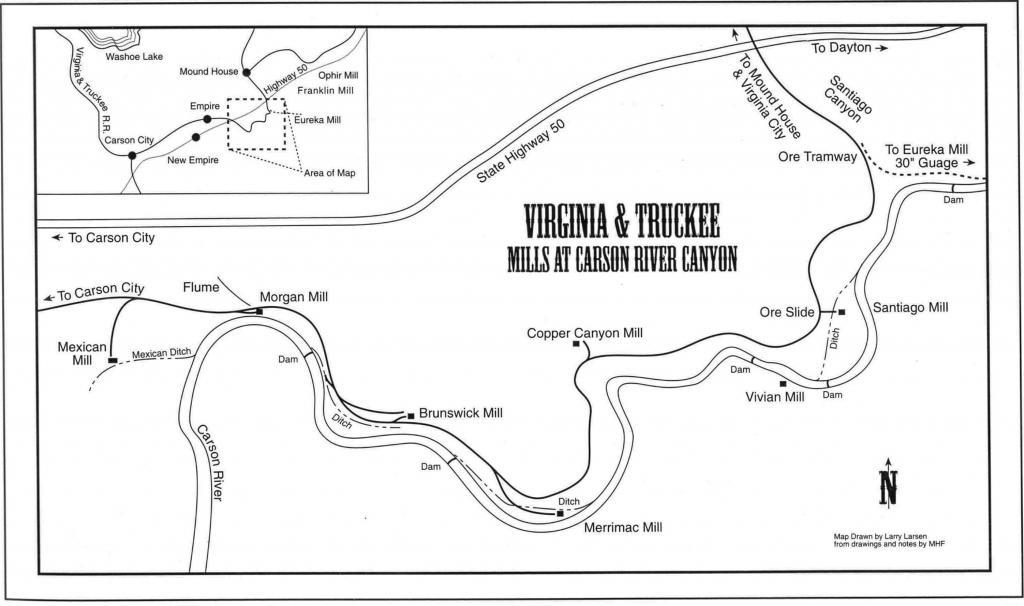
This map of the Carson River Canyon was drawn by Larry Larson, for the Mallory Hope Ferrell book The Bonanza Road. It shows the path of the V&T Railroad through the Carson River Canyon, and the locations of the mills in the canyon. Sidings to each of the mills are shown too

Actions

⇓ Download This Photo

To download this photo, choose a size below, then right-click and select "Save As".

200x118 | 250x148 | 500x296 | 800x473 | 1024x606 | 2048x1212 | 3003x1777

⇓ Embed This Photo

To embed this photo in a blog or web page, choose a size below, then copy and paste the HTML or wiki code from the box.

200x118 | 250x148 | 500x296 | 800x473

HTML code

Wiki markup

Other Data

Date Uploaded: January 26, 2009

Permanent Link: http://wnhpc.com/details/tbr0023

Source: Virginia and Truckee: The Bonanza Road


Post A Comment