Virginia City, 1867

Tags: comstock , virginiacity

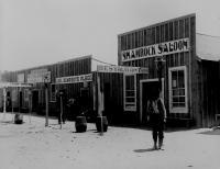
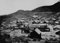
Date of photo: 1867-68

Photographer: Timothy O'Sullivan

Source : U.S. Geological Survey

Available Sizes: 1024x762 | 2048x1524 | 6000x4465

Download: JPG (3610 KB)

United States Geological Exploration of the Fortieth Parallel (King Survey)

Description

This best general view of Virginia City looks down on town from an outcropping to the north. At the bottom of the picture you can see the Geiger Grade wagon road wind its way into town and turn into C Street, passing right through downtown.

Other Data

Date Uploaded: January 1, 2008

Permanent Link: http://wnhpc.com/details/west152

Source: U.S. Geological Survey

Source URL: https://www.sciencebase.gov/catalog/item/51dd6c68e4b0f72b4471a02f

Source Caption: View of Virginia City, Nev. , from a nearby hillside, 1867--68. By O'Sullivan. 77-KN-93 1/2

Download Photo: JPG (3610 KB)

Location

← Previous Photo

Gold Hill, 1867

Next Photo →

Hazen Saloons