← Previous Photo
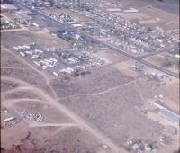
Carson City Aerial
Next Photo →
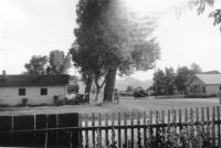
Frontier Motel

Carson City Aerial

Date of photo: 1965-66
Photographer: Unknown

Source: Facebook

Tags: aerial, carsoncity,

Available Sizes: 800x478 | 1024x613 | 1500x898

Description

Looking at north Carson from the air. Carson Street stretches away to the end of the valley, still mostly undeveloped. A new housing development on the left clusters around Mountain Street. The bright scar of Northgate Lane leads away to the right, with only a few houses and trailer parks built up. Lone Mountain is seen at the lower right, just next to it is the future intersection of Roop and Winnie, which is still sagebrush.

Actions

⇓ Download This Photo

To download this photo, choose a size below, then right-click and select "Save As".

200x119 | 250x149 | 500x299 | 800x478 | 1024x613 | 1500x898

⇓ Embed This Photo

To embed this photo in a blog or web page, choose a size below, then copy and paste the HTML or wiki code from the box.

200x119 | 250x149 | 500x299 | 800x478

HTML code

Wiki markup

Other Data

Date Uploaded: June 8, 2013

Permanent Link: http://wnhpc.com/details/photo0366

Contributor: Rick Lee on Facebook

Source: Facebook

Source URL: https://www.facebook.com/photo.php?fbid=515119908554964&set=oa.515650461821494


Post A Comment