From Highway #17 - Nev

Tags: geigergrade , steamboatsprings

Date of photo: 1947

Photographer: Jervie Henry Eastman

Source : UC Davis, University Library, Special Collections

Available Sizes: 1024x664 | 2048x1328 | 2444x1585

Download: JPG (552 KB)

Eastman's Originals Collection

Description

Looking west from the Geiger Lookout, along the new Geiger Grade between Virginia City and Reno. The valley below is labeled Washoe Valley, but it's not. It's an area along Hwy 395 between Reno and Carson marked on maps as Steamboat Valley. It's also known as the Andrew Lane neighborhood. To the right is Steamboat Springs. In the distance Slide Mountain and Mount Rose are labeled. The Old Geiger Grade is labeled too. This is now known as Toll Road and it is lined with houses.

Other Data

Date Uploaded: July 7, 2024

Permanent Link: http://wnhpc.com/details/b5245

Source: UC Davis, University Library, Special Collections

Source URL: https://calisphere.org/item/ark:/13030/tf8h4nb48m/

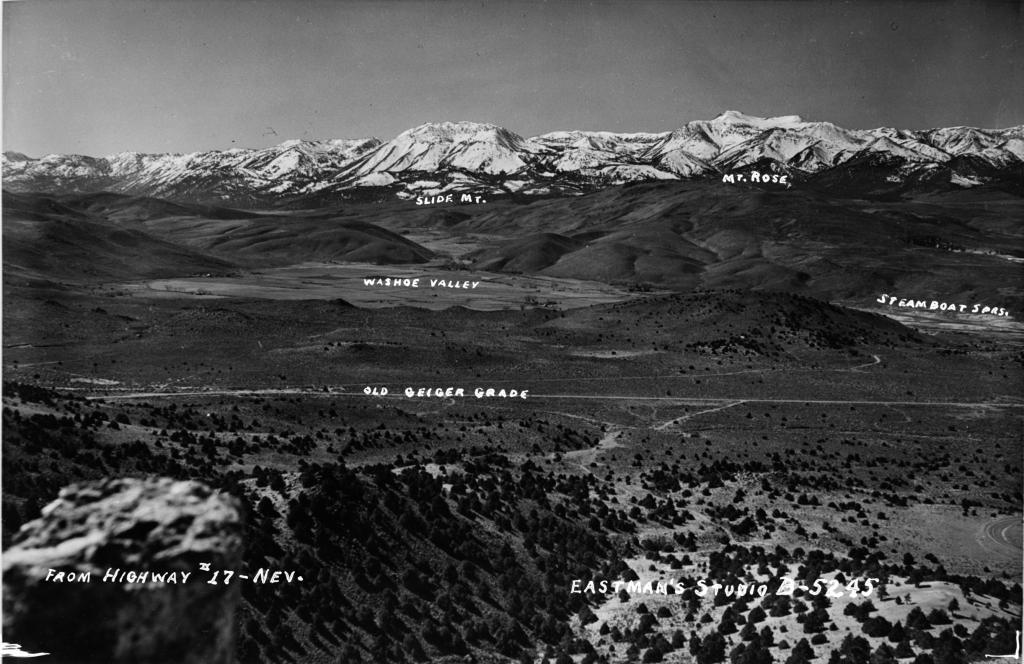
Source Caption: From Highway #17 - Nev. Photograph of a photograph of road through valley with snow-covered mountains in background (names of areas printed on negative). Caption on envelope reads "Slide Mt. & Mt. Rose from Geiger Lookout, Nev."

Download Photo: JPG (552 KB)

Location

← Previous Photo

Geiger Lookout

Next Photo →

Truckee River