
← Previous Photo | Next Photo → |
Indian Hills, 1984
Date of photo: June 1984
Photographer: Unknown
Source: Scanned Slide

Description
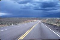
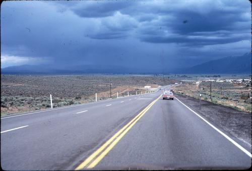
This is the view from a car driving south down Hwy 395 into Indian Hills, approaching Mica Drive. What's remarkable about this photo is the amount of development that has sprung up since it was taken. First of all, Hwy 395 is still two lanes here. The road wasn't widened to its current four lanes for another couple of years. But there is a passing lane on the northbound side, so trucks that are having trouble climbing the hill don't bring traffic to a halt.
Missing is the entire Sunridge development, which enveloped those rolling hills on the left in the 1990s. The subdivision now sprawls as far as can be seen in this photo. There is also no stoplight at Mica Drive, and no gas station at the corner.
An impressive June thunderstorm is mobilizing in the distance too. Looks like it's going to hit in less than an hour. Drops are probably already falling in the Ranchos.
Actions
Other Data
Date Uploaded: March 6, 2008
Permanent Link: http://wnhpc.com/details/slide0001
Source: Scanned Slide
View on Flickr: https://www.flickr.com/photos/scottschrantz/2315900548
Jeff Garner said:
on Tuesday, March 5, 2013 at 05:30 PM
This is fantastic how rural it is. Wish it was like that again - life was slower!