
← Previous Photo | Next Photo → |
Downtown Reno
Date of photo: 1979
Photographer: Unknown
Source: Facebook: Old Reno

Description
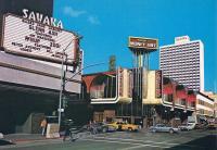
The corner of Second and Sierra in downtown Reno. From left to right are the Sahara Reno, the Mapes Money Tree, and the hotel tower of Harrah's Reno in the background.
Actions
⇓ Download This Photo
⇓ Embed This Photo
Other Data
Date Uploaded: January 29, 2017
Permanent Link: http://wnhpc.com/details/fb1633861060239997
Contributor: Old Reno on Facebook
Source: Facebook: Old Reno
Source Caption: At the corner of West Second Street and North Sierra Street around 1979 are the Sahara Reno and Mapes Money Tree, with the Harrah's Reno hotel tower in the background.
Post A Comment