Saturday, October 25, 2008

This view from high above Carson City shows most of downtown, with the Capitol Building at the center. There’s much about this photo that has changed in the 40-50 years since it was taken. To the south (right) of the Capitol, the whole Capitol Plaza and Legislature Building have not been constructed yet. Instead there is still a sprawl of scattered houses and commercial buildings, along with the Nye state office building. The brick buildings right across 2nd Street from the Capitol date back to the 1860s, when Carson City was just a few years old.
To the north of the Capitol, you can still see the Senator Cafe standing at the corner of Carson and Musser.
Looking out to the east of town, the last street is Harbin Ave, and beyond that is nothing but empty pasture. Also notice how none of the streets, like Roop and Stewart, go all the way north to connect with William Street (Hwy 50). That’s because that empty area used to be the V&T Railroad yards. The tracks were torn up, but the land hadn’t started to be developed yet.
This was a simpler time for Carson City, but also this shows Carson right at the precipice of the explosive growth that occurred in the mid 20th century. In about 20 years time, Carson City went from a small town clustered around the Capitol to a sprawling town that filled up the Eagle Valley in every direction. In this photo we were right at the edge.
Wednesday, October 22, 2008
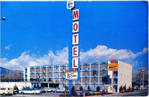
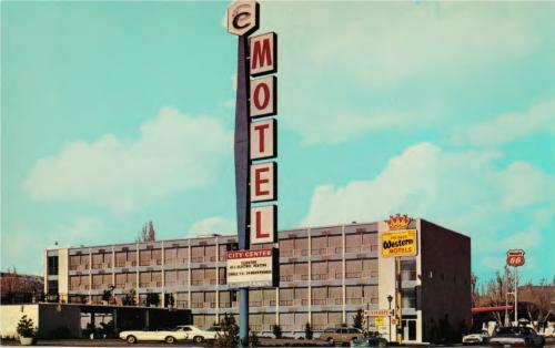
The City Center Motel at the northwest corner of Carson and Washington is seen in what appears to be the 1970s, judging by the cars. The Best Western crown stands proudly by the motel, but it is overshadowed by the motel’s own sign, reaching high into the sky.
Wednesday, October 22, 2008
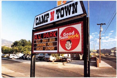
The Camp N Town RV Park sits right on North Carson Street, near the intersection with Hot Springs Road. It’s a “Good Sampark” and “A good place to park your RV.” They offer a swimming pool, arcade, laundry, and of course, liquor and gambling.
This sign still stands at the north end of town, but what is most notable about this photo are the things that are almost not in it. Look at the far right to see signs for some of the other North Carson businesses that no longer exist. The 49er Motel. The Scolari’s supermarket, and the Thrifty Drug.
Wednesday, October 22, 2008

This postcard looks down on Carson City from great height during the 1990s. The view is to the southwest, and the town can be seen butting right up to the bottom of C Hill.
Since this photo is so recent, not much has changed since it was taken. But even at this altitude, there are a few notable things that can bracket the date of the photo. For one, the old V&T Enginehouse is not there. The large dirt scar just below and to the right of center marks the site where the “Old Stone Fort” sat for nearly 120 years, until its demolition in 1991.
A few other details can be seen that place the photo squarely in the 90s. The Penguin Drive-In, at the corner of Carson and Sophia, is still standing. That old-time burger stand was torn down around the turn of the millenium. A few blocks away, Caroline Street still runs next to the Nevada State Museum. That stretch of road was abandoned in 1999 to make way for a public plaza north of the museum. And way down at the south end of town, the Target (opened 2000) and Super Wal*Mart (opened 2002) are nowhere to be found.
The astute among you can find many other changes in the ten years or so since this photo was taken, I’m sure.
I managed to grab a super-duper high-res version of the Bird’s Eye View of Carson City. But, of course, I also discovered that there’s some kind of bug in the site that’s not letting it display full-res pictures right now. So until that’s solved, you can look at the 2048 pixel version, which is great in its own right.

I added today a few pictures of famed stagecoach driver Hank Monk.


The Nevada Appeal today has a story about Carson City’s Chinatown, and included three pictures with it.


